Saturday, November 10, 2012

Milkweed along the South Branch

Milkweed (Asclepias syriaca) along the South branch of the Potomac.  Last year we began culturing milkweed for schools with butterfly programs.


Milkweed sap has toxins called cardiac glycosides. When the caterpillars of the Monarch butterfly (Danaus plexippus) and other milkweed butterflies (subfamily Danainae in the family Nymphalidae) ingest the leaves of milkweed, the glycosides make the caterpillar poisonous to some predators. Adult butterflies retain the glycosides.

This useful table was prepared by students in Fairfax County Public Schools:

Animals Using as Food SourceAnimals Using as ShelterAssociations With Other Plants
OTHER
MonarchGoldenrod SpiderSilver MapleEastern Yellow Jacket Po
Milkweed BugAmerican Dog TickPokeweedChinese Mantid FP
Green LacewingChinese MantidSmooth CrabgrassAmerican Dog TickFP
Eastern Tiger SwallowtailAmerican GoldfinchQueen Anne's LaceRuby-throated Hummingbird Po
Painted LadyBlack and Yellow ArgiopeSmooth SumacEastern Tiger Swallowtail Po
Mourning CloakCarolina ChickadeeRed CloverClouded SulphurPo
Great Spangled FritillaryEastern MoleDevil's Beggar-tickHoney Bee Po
BuckeyeWhite-footed MouseLamb's QuartersMourning Cloak Po
Eastern Black SwallowtailGreen LacewingCommon RagweedPainted Lady Po
Pipevine SwallowtailJimsonweedGolden Northern Bumble Bee Po
Pearl CrescentBlack-eyed SusanGreen LacewingFP
Honey BeeBushy AsterPipevine Swallowtail Po
Golden Northern Bumble BeeKentucky BluegrassMonarch Pa
Black Carpenter AntCommon MulleinOrgan-pipe Mud Dauber Po
Ruby-throated Hummingbird
Cicada Killer
Eastern Yellow Jacket
Fungus Gnat
Clouded Sulphur
Bald-faced Hornet

Monday, November 5, 2012

Smithsonian Chestnuts

I took my dad, who maintains the Boyd American Chestnut nursery in Pennsylvania, to help winterize the Smithsonian Museum's nursery near Front Royal, Virginia.  Other members of the team recorded individual tree data.

The Smithsonian interns got practice driving in four-wheel drive on side slopes.

Saturday, November 3, 2012

Training Young Trees


Structural pruning on young trees will prevent a lot of the storm damage in mature trees.  Now University of California has a great on line video for home use.

Training Young Trees is simplified for home gardeners, but horticulture educators and green industry professionals can also benefit from this resource. The 18-minute video and its shorter chapters are available free at their YouTube Channel:  http://tinyurl.com/trainingyoungtrees.


  • Thumbnail18:53Training Young Trees39 views  1 month ago
  • Thumbnail0:51Chapter 1: Introduction6 views  1 month ago
  • Thumbnail1:20Chapter 2: Why Train Young Trees?1 view  1 month ago
  • Thumbnail0:49Chapter 3: What Does A Well-Trained Tree Look Like?2 views  1 month ago
  • Thumbnail0:55Chapter 4: What's the Investment?1 view  1 month ago
  • Thumbnail0:49Chapter 5: When Do I Prune and How Much?1 view  1 month ago
  • Thumbnail0:52Chapter 6: The 5 Steps to Training Young Trees5 views  1 month ago
  • Thumbnail0:48Chapter 7: Step 12 views  1 month ago
  • Thumbnail1:04Chapter 8: Step 23 views  1 month ago
  • Thumbnail1:14Chapter 9: Step 33 views  1 month ago
  • Thumbnail1:18Chapter 10: Step 41 view  1 month ago
  • Thumbnail0:58Chapter 11: Step 54 views  1 month ago
  • Thumbnail4:41Chapter 12: The 5 Steps in Action2 views  1 month ago
  • Thumbnail1:07Chapter 13: Tree Response to Training Over Time2 views  1 month ago
  • Thumbnail2:14Chapter 14: Summary and Review2 views  1 month ago

  • Tuesday, October 30, 2012

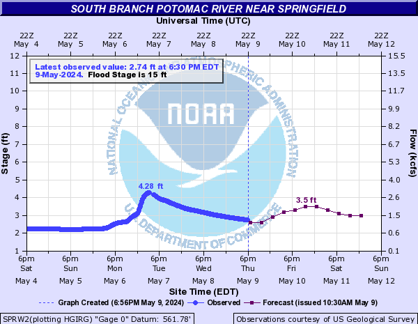
    River Level Predictions (updated 10/30 10:15am)

    NOAA 72 hour, river level predictions are understandably and necessarily conservative.  As an example, our road floods at around eight feet, so I appreciate knowing about the possibilities in advance.  NOAA also publishes the likelihood of specific river levels based on historical modeling, if you want to decide for yourself.

    So I'm doing an experiment here.  I'm publishing static images of the gauge prediction (hydrograph) throughout the storm, and then also publishing the automatically updated version of the hydrograph at the bottom of this post.

    The Satuday, 10/27 prediction for Tuesday at 7am, copied at 7pm, Saturday, 10/27/2012:

    Snapshot Saturday, 10/27/2012, 7pm

    Here is another forecast, almost 41 hours later (Monday at 1:15pm) than the one above:


    A significantly reduced threat - 10am on Tuesday (10:15am)


    The live (automatically updated) image for the same gauge:

    Automatically update image.

    Monday, October 29, 2012

    NASA Super Rapid Scan Video

    This is from the NASA Earth Observatory YouTube Channel.  There's lots of great Hurricane Sandy video there.

    Sunday, October 28, 2012

    Construction Progress

    We've nearly enclosed our new 60x36 shop, garage, and future teacher-training center along the South Branch.


    Saturday, October 27, 2012

    This is going to be bad.

    This rainfall projections continue to evolve.  At 5:30am, the entire West Virginia portion of South Branch watershed (everything downstream of Bluegrass, Virginia) was within the 6" rainfall zone.  (Click to enlarge and check the lower left corner for the last update.)
    http://www.hpc.ncep.noaa.gov/qpf/zoom/Rainfall_Days_1-5.gif

    Wednesday, October 24, 2012

    Alternative Agriculture

    We have lots of inexpensive land in Hampshire County, and you can still find larger tracts of land for under $5000/acre.  But just 100 miles east, there are several places where land sells for over $5 million an acre, or closer to $8 million per acre in commercial districts.  People there are exploring alternative agriculture practices that could be replicated in backyards, porches, or even rooftops, just about anywhere.   In this video clip, you'll see an Oakland, California man has developed small-scale, high output practices with very low impact on the environment.

    Friday, October 19, 2012

    Saturday, October 13, 2012

    Frosty morning in Hampshire Co.?

    Our temperatures fell to just below freezing along the river here in Green Spring, WV, but because we're down here at 600', surrounded by mountains on four sides and the river on three sides, we did not have a frost.  However, our friends up on Jersey Mountain, including Steve and Ruth at Church View Farm, apparently received a heavy frost.  Tell us where you are and whether you were frosted this morning.


    Yes, I know the "North Fork South Branch Potomac River" label on the Google map above is wrong.  We've reported it.

    Friday, October 5, 2012

    From Meanders to Mitigation: FEMA Flood Maps

    From Lauren's Meanders to Mitigation blog: FEMA Flood Maps:

    If anyone is interested in learning about floodplains and how that information is used for flooding mitigation, flood zone delineation, and building requirements, here is a link to the Map Service Center. Let me know if you have any questions about using the site!

    Monday, October 1, 2012

    Fall and Winter Gardening


    Shared by the Homesteading Survival Blog:  Free for Kindle right now. Fall and Winter Gardening: 25 Organic Vegetables to Plant and Grow for Late Season Food


    Fall and Winter Gardening: 25 Organic Vegetables to Plant and Grow for Late Season Food